News
Protecting Peaceful Places
We commissioned research to measure tranquillity levels across the Lake District. Now we can help protect this special quality for generations to come
Measuring tranquillity
Working with Wild Land Research Limited and Lune Geographic, Friends of the Lake District has developed a method for assessing and measuring tranquillity levels across the Lake District – essentially answering the question ‘where are the peaceful places, and what makes them so’?
This means we now have objective evidence to point to to help us defend peaceful places from harmful developments or decisions about their management.
Download the final report on tranquillity in the Lake District here.
Amongst – and despite - the busy-ness, many of us know where and when to find peaceful places in the Lake District, and we know this is an important part of why the National Park is so special. Being able to access peace and quiet, calmness and natural surroundings is crucial for our health and well-being. It also provides opportunities to really understand, enjoy and immerse ourselves in the Park’s special qualities.
The problem with measuring tranquillity
The tricky bit though is that tranquillity is about how a place makes us feel. What makes one person feel calm and peaceful may not be the same for someone else. It’s very subjective, and that makes it hard to measure. This also means it’s difficult to defend when threatened.
At the court case in spring 2025, relating to the proposed Zip World development at Elterwater, the judge made the comment that ‘tranquillity can’t be measured’, suggesting that this made it impossible to make a case for whether something would or wouldn’t impact on tranquillity. In a National Park where opportunities for ‘quiet enjoyment’ is one of the identified special qualities and where tranquillity is a key characteristic of the landscape, it is vital that peace and quiet can be measured and monitored.
The idea of this research then wasn’t to identify and broadcast where the remaining quiet, calm and peaceful spots are, but to establish a method of identifying and assessing them in a defensible way. It also had to be a way that could be readily repeated in future, so that changes can be measured over time, meaning we can demonstrate where decisions are affecting this, whether positively or negatively.
Research
The research began by mapping known fixed elements within the National Park. These elements, which affect how peaceful, calm and tranquil a place can feel, were informed by the Campaign to Protect Rural England (CPRE). These elements include factors known to have a negative effect for most people, such as roads, built-up areas and high recreational use, and those known to have a mostly positive effect, such as water, open views and woodland. Each factor was assigned a weighting, again informed by past CPRE research, then various digital geographic tools were used to calculate the impact of each factor in any given location in the National Park, using the weighting and taking factors such as distance and topography into account. A visualisation of this impact was then created on a map by assigning a colour to the figure generated.
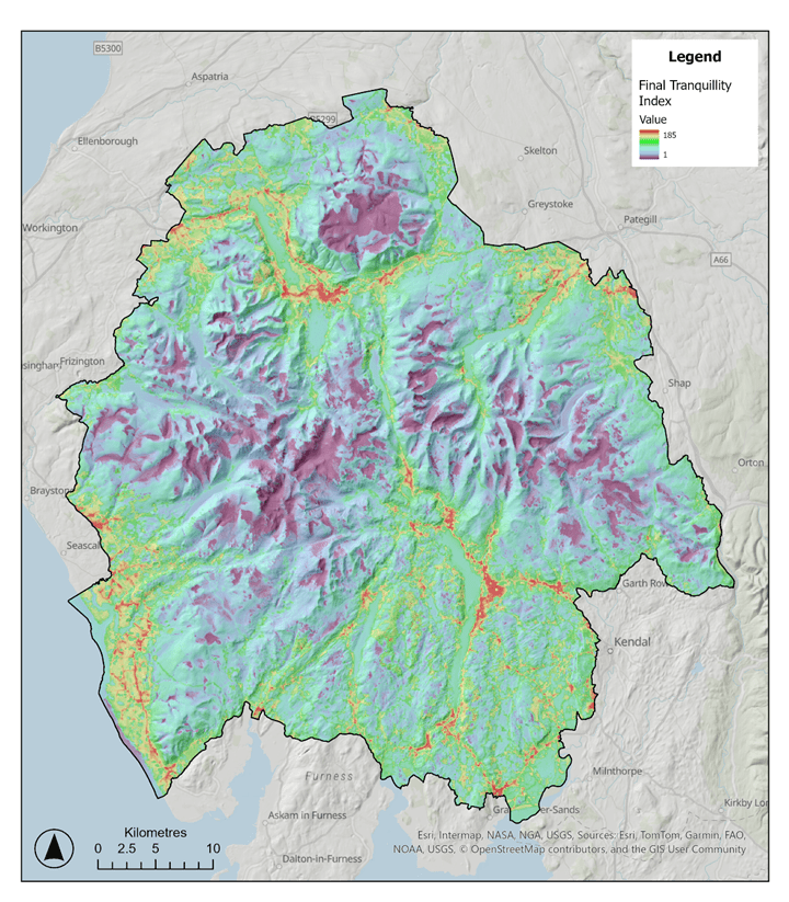
The second part of the research involved the public. Several of our members and supporters were amongst those who took part in an exercise to identify which places in the Lake District they consideredpeaceful or tranquil, and why. These results were then also mapped, enabling us to test and corroborate the results of the first stage.
Results
The results of the first stage of the research and the public participation closely matched each other. In both cases, the areas identified as most peaceful, calm or tranquil are mainly in the remote high fells and isolated valleys, where there is least exposure to features that detract from peace and tranquillity, while the areas identified as least calm and peaceful align with major transport corridors and tourist hubs.
Although this is what we expected, this work means that we are now able to provide firm, objective evidence of the level of peace and tranquillity for any given part of the Lake District. This is vital when we’re working to protect the places that are peaceful from proposals that will harm them (or seeking to ensure that tranquillity is not further eroded in other areas), as well as when we’re calling for more nurturing and regenerative approaches to managing the Park.
Interestingly, the work also showed that there is a relationship between how busy with people a place is, and how tranquil one feels there. Even in areas where there are multiple factors detracting from peace and calmness, where there is lower recreational use (less others around) people generally felt these areas were more peaceful than in areas where there were fewer detracting factors, but where recreational use was high.
We’ve already begun to use the research, sharing it with relevant organisations so that it can inform their work, including the Lake District National Park Authority and the Lake District National Park Partnership, so that it can be referred to in decision-making and the drawing up of the new management plan for the Park. For example, the research shows the stark impact of roads, transport routes and traffic on the peacefulness of an area, further backing the case for a transformative approach to transport in the Park.
We’ll also use the evidence in our own planning responses, to influence both planning proposals and local and national planning policies, and in other work we are involved in such as piloting a method to monitor wider landscape change.
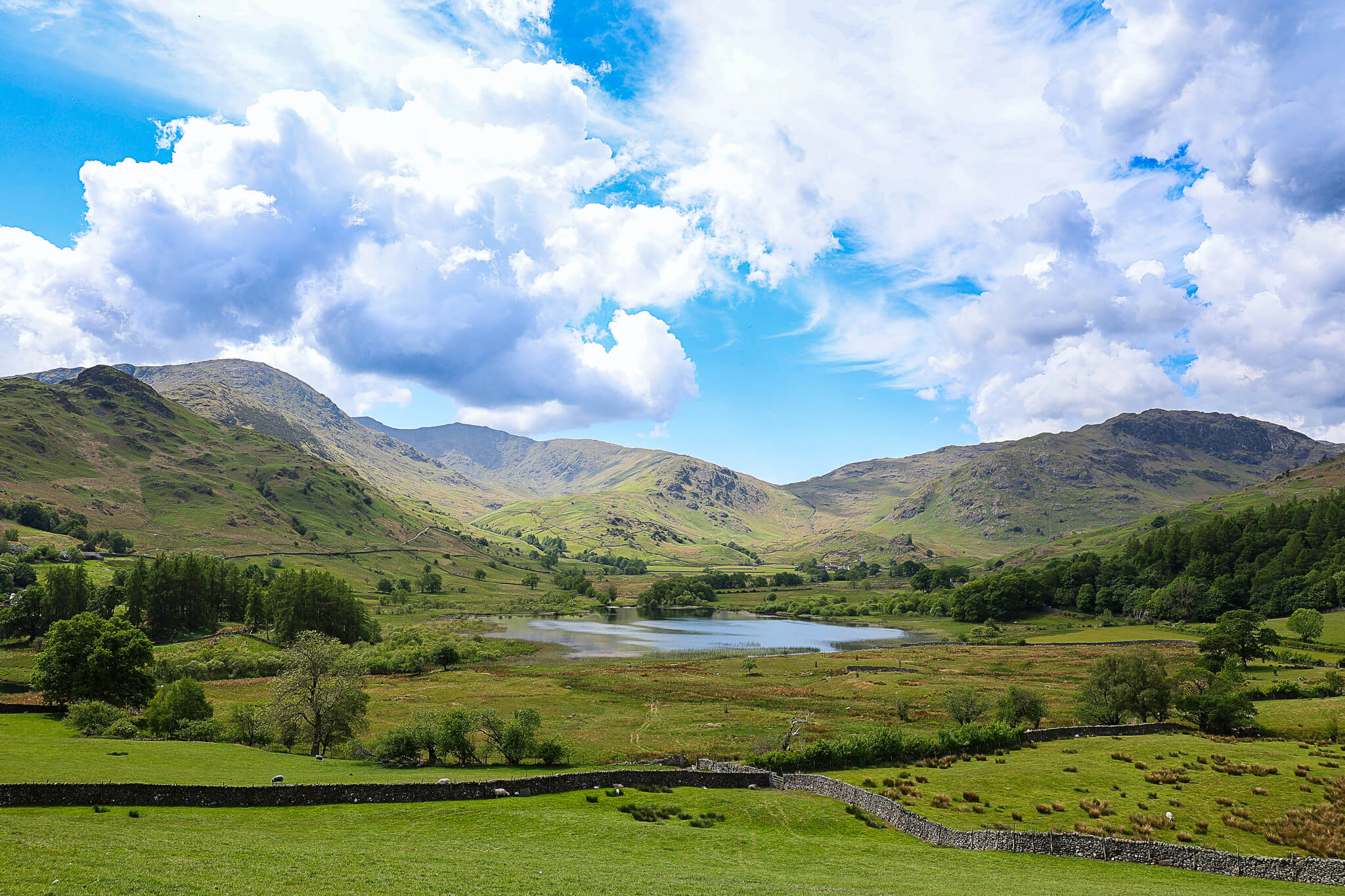
Main image: Little Langdale Tarn (Alan Hassey)
Share this post
Related posts
Updates from our campaigns, our land, and the people taking action for the Lakes.

Our new website
The website as you see it now is just the start. Much of our previous content is temporarily…

Great Cumbrian Litter Pick 2026
We’re hoping lots of people across the county will help us with an annual spring clean on Friday…
Annual Hedge Laying Results 2026
Results of this year’s hedge laying competition which took place on Saturday 21 February at Gowbarrow Hall Farm,…